Photo by Photo Submitted
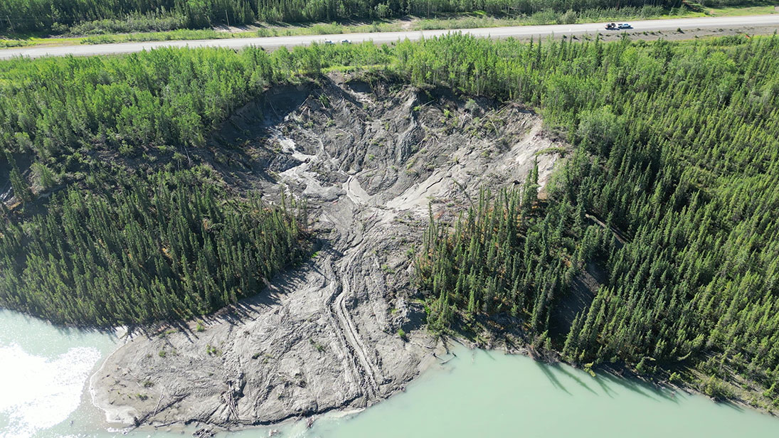
A FLUID PHENOMENON – A drone photo taken Wednesday shows the small Alaska Highway slump on the left and the bigger one on the right. Photo courtesy YUKON UNIVERSITY
Photo by Photo Submitted
A FLUID PHENOMENON – A drone photo taken Wednesday shows the small Alaska Highway slump on the left and the bigger one on the right. Photo courtesy YUKON UNIVERSITY
The Department of Highways and Public Works has decided to reroute the Alaska Highway away from the area that is slumping close to the highway in the Ibex Valley.
The Department of Highways and Public Works has decided to reroute the Alaska Highway away from the area that is slumping close to the highway in the Ibex Valley.
Department communications officer Madison Guthrie said Thursday a decision was made to relocate the highway about 60 metres to the west of the slumping area located in the vicinity of the Takhini Bridge.
The cost of relocating the highway is estimated at $2 million. That does not include additional maintenance work that will be undertaken at the same time, such as replacing a highway culvert, she said.
In an emailed press release, the department says it has been working to find a solution to the thaw slump area.
“Thawing permafrost in the area is causing the ground to slump, and the affected area has expanded into the highway right-of-way. Long tension cracks have formed near the highway, causing concern for the long-term viability of the road.
“We have been collaborating with Yukon University to understand the active thaw slump and develop a mitigation plan,” says the release.
“Based on our work with Yukon University, we considered several options but decided realigning the highway was the best long-term solution.”
The realignment will protect highway infrastructure and public safety by expanding the the buffer between the active thaw slump and the highway.
The tender for the project closed on June 26.
Guthrie said the contract has not yet been awarded but will be soon.
The relocation work is expected to be completed this summer but if it’s not, it will carry over to next summer, she said.
Guthrie said they do not expect to see traffic disrupted, and if there is any, it will be minimal.
The government has been monitoring the slump since 2019, when it learned about it and they will continue to monitor it in the future, Guthrie said.
Fabrice Calmels, a doctor of geology at Yukon University, explained in an interview Thursday the slumping in the ground occurs when the permafrost is exposed and begins to melt.
Calmels said there are likely more areas in the Yukon and N.W.T that are slumping, although they don’t know of them unless thay are told about them or they are seen from the air during unrelated work.
He said they learned of the Takhini slump in 2019 because they were told about it.
As for how much the slump has grown, they won’t have a good idea until the end of the summer, when aerial surveys are studied and slumps are measured.
He does estimate the slump travels about 30 metres per year.
The size of the Takhini slump was estimated in 2019 to be about to be about 78 metres long and 58 metres wide.
In May 2019, the distance of the headwall from the riverbank was 78 m; the measured maximum width 53 m; and the distance from the road 81 m.
This month, July, the distance of the headwall from the riverbank is 120 m; the measured maximum width is 115 m and the distance from the road 25 m.
The two slumps are still active and will remain so until the ground freezes up again, Calmels explained.
In order to encourage thoughtful and responsible discussion, website comments will not be visible until a moderator approves them. Please add comments judiciously and refrain from maligning any individual or institution. Read about our user comment and privacy policies.
Your name and email address are required before your comment is posted. Otherwise, your comment will not be posted.
Be the first to comment