Photo by Photo submitted
FIRE CONTINUES - Firefighters are continuing to battle the XY forest fire burning 60 kilometres northeast of Whitehorse. Photo courtesy Wildland Fire Management
Photo by Photo submitted
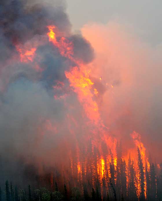
FIRE CONTINUES - Firefighters are continuing to battle the XY forest fire burning 60 kilometres northeast of Whitehorse. Photo courtesy Wildland Fire Management
Wildland Fire Management officials have lifted its ban on campfires throughout the territory.
Wildland Fire Management officials have lifted its ban on campfires throughout the territory.
"The message is still be careful," fire information officer George Maratos said early this afternoon, stressing that fires should only be lit when necessary and should be fully extinguished at the end of the night.
Decreasing temperatures have allowed fire officials to lift the ban on campfires, he said.
Throughout the territory most regions are listed as being in a high danger, which means the ban reamains on permit fires.
The Carmacks fire district is the only area which continues to be listed with an extreme danger rating for fires.
Along with urging campers to be extremely cautious with campfire, officials also remind hunters to be cautious about where they venture out to.
"Due to the current hot and dry conditions and volatile fire behaviour, hunters are being asked to avoid areas of fire activity if possible or delay their trips until the fire situation eases," notes this morning's fire report from Wildland Fire Management.
Four new fires, all caused by lightning, began on Thursday, with two each in Ross River and Watson Lake.
The first was spotted at 6:45 p.m. when aircraft patrols discovered a 100-hectare blaze near the Yusezyu River, about 140 kilometres north of the community.
Then about two hours and 15 minutes later, aircraft patrols spotted the other fire in the Watson Lake district, west of the Coal River, about 95 kilometres northeast of the town. It's about 10 hectares in size.
A total of 33 fires in the district have burned more than 35,508 hectares this season there. Six blazes are continuing to burn in the region.
Meanwhile, in the Ross River area, a 15-hectare blaze was confirmed just before 7 p.m. by satellite detection at Summit Creek, about 150 kilometres northeast of the community, the same direction as the second fire, about 140 kilometres away from town. It is three hectares.
A total of seven fires have burned more than 367 hectares there this year.
While no properties are deemed to be at risk in either Watson Lake or Ross River, an evacuation alert remains in effect for those living or visiting areas affected by the Little Salmon Lake fire in the Carmacks district.
"This includes all structures along Little Salmon Lake and the Magundy River drainage corridor adjacent to the Robert Campbell Highway," reads the fire report.
"Residents may be asked to leave their homes on very short notice. Those residents who have not yet checked in at the stations are encouraged to do so."
At 38,000 hectares, the fire has shown little growth to the northeast; however, the southeast has had significant behaviour. Crews, ignition specialists and aircraft are being used to fight the fire.
Also being monitored is another blaze in the district, which has seen 11 fires throughout the season, burning more than 53,217 hectares.
In Teslin, cloud cover and lower temperatures have helped bring down the risk of fire activity, though a 5,220-hectare fire burns on the south side of Teslin Lake while a 550-hectare blaze continues to burn on the south side of Quiet Lake.
The district has seen a total of five fires burn 5,770 hectares this season.
In Dawson, conditions continue to be smoky due to existing fires. Officials are recommending residents be cautious when they are out in the woods.
The district has seen 24 fires burn more than 106,693 hectares this season.
Meanwhile, in the Whitehorse district, the Teslin River fire has grown thanks to the hot, dry conditions. It is burning 60 kilometres northeast of the city and is at 27,500 hectares.
The region has had 24 fires burn more than 27,667 hectares.
While the Haines Junction district has seen the lowest amount of land burned this season at 0.51 hectares from three fires, Old Crow has had the lowest number of blazes at just two, though they burned more than 1,173 hectares.
Finally, Beaver Creek saw three fires burn more than 355 hectares this season while Mayo had four burn more than 226 hectares.
Joining Yukon firefighters in dealing with the blazes are an additional 28 from Alberta, along with 11 other personnel who arrived early this morning to replace a previous contingent from the province.
A total of 78 firefighters and 19 personnel from both Alberta and the Northwest Territories are in the Yukon now along with an airtanker group from Alberta.
In order to encourage thoughtful and responsible discussion, website comments will not be visible until a moderator approves them. Please add comments judiciously and refrain from maligning any individual or institution. Read about our user comment and privacy policies.
Your name and email address are required before your comment is posted. Otherwise, your comment will not be posted.
Be the first to comment