Photo by Vince Fedoroff
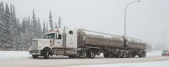
THE JOYS OF ‘SPRING' – This semi got stuck on a slippery Two Mile Hill this morning. The blizzard which hit the southern Yukon overnight and this morning may extend the cross-country ski season.
Photo by Vince Fedoroff
THE JOYS OF ‘SPRING' – This semi got stuck on a slippery Two Mile Hill this morning. The blizzard which hit the southern Yukon overnight and this morning may extend the cross-country ski season.
Whitehorse RCMP are reporting three vehicle rollovers directly related to treacherous road conditions created by the unexpected record dump of snow this morning.
Whitehorse RCMP are reporting three vehicle rollovers directly related to treacherous road conditions created by the unexpected record dump of snow this morning.
Const. Christine Grant said early this afternoon there were no injuries reported from the rollovers. They occurred on the Alaska Highway at the turnoff to Mount Sima, in the McRae area and at Wolf Creek.
And there were a couple of other minor fender-benders related to the slippery conditions, she said.
Grant suspects a fair number of motorists had already removed their snow tires.
But Yukoners especially should know you have to drive according to the conditions, she said.
Grant said in addition to the Wolf Creek rollover reported at 10:19, there were two other vehicles in the ditch in the Wolf Creek valley at the same time.
One motorist said as she left her Wolf Creek home shortly before 11 a.m., she saw what appeared to be a temporary highway closure at the top of the hill leading down into valley.
Another motorist said when he came into town from the north end at about 8:30, it appeared that neither the Klondike or Alaska highways had been plowed – or had quickly filled in with snow again after having been plowed.
Department of Highways spokeswoman Jennifer Gehmair said this afternoon highway staff were out at 6 a.m. with their fleet of plows and sanders.
The priority is given first to the area from the Takhini Hot Springs Road to the Carcross Cutoff, before crews move further afield, she said.
City of Whitehorse public works manager Dave Muir said they had a night crew on last night, as part of the regular scheduled shift to the end of April, but oddly enough, they were doing spring cleaning.
It wasn't until later in the morning, at around 6:30 and 7:00, that the snow really hit the city, he said.
Muir said the city had three sanders out sanding intersections and two graders out looking after number one and two priority roads, as well as a crew clearing and sanding sidewalks.
Depending on how the day goes and what's expected for the night will largely determine whether they call in another night crew, he said.
"If we have to bring in extra staff either tonight or tomorrow, that's what we'll do.”
Muir said the city doesn't put away its winter gear until well into the spring, for precisely this reason.
"We had the same thing happen to us last year,” he recalled.
Meteorologist Doug Lundquist of Environment Canada said the 10 to 11 centimetres that fell from 5 a.m. until noon today was a record for April 18.
Records going back to 1942 show the next-largest snowfall for this day was 5.1 cm in 1947, he said from his office in Kelowna, B.C.
Lundquist, however, said while April is generally a dry month with little snow or rain, it's no stranger to large dumps of snow in a single day.
In 2006, 17 centimetres fell in the city on April 14, 16 cm were recorded on April 15, 1967, and nine cm fell on April 25, 1999, he said.
Lundquist said another five centimetres are forecast for overnight tonight.
This morning's snowfall, he added, was the result of a perfect spring storm.
"We had an upper low pressure system combined with moisture and instability moving in from the North Pacific or the Gulf of Alaska, combined with Arctic air moving in over the Yukon,” he said.
Lundquist said things could look much different for Sunday.
The forecast is calling for a high pressure system to begin building in the west and travelling east, bringing much more sunshine and temperatures of six and seven degrees by Sunday.
There is a little Arctic air stirring up north but if it stays up north, temperatures should climb heading into next week, he said.
"The highest probability is for warmer conditions, but there is always a fly in the ointment somewhere, though.”
In order to encourage thoughtful and responsible discussion, website comments will not be visible until a moderator approves them. Please add comments judiciously and refrain from maligning any individual or institution. Read about our user comment and privacy policies.
Your name and email address are required before your comment is posted. Otherwise, your comment will not be posted.
Be the first to comment