High water spurs concerns in several areas
Various regions around the Yukon are now under flood alerts of various kinds.
By Tim Giilck on June 13, 2022
Various regions around the Yukon are now under flood alerts of various kinds.
Ross River appears to be perhaps the hardest-hit area at the moment, with the Yukon government issuing an evacuation alert for the village on Sunday.
Properties along the Canol Road between Sawmill Road and the Pelly River ferry landing are under the alert.
“Flood response staff have notified people at seven primary residences and eight other sites in this area, (they) should be ready to leave within an hour if needed.”
According to the statement, the Canol Road, including the pedestrian bridge across the river, is also closed to non-local traffic north of the Pelly Road because of fast-flowing water and heavy equipment using the area.
The ferry is also closed.
“The Pelly Barge is currently inactive due to high water and strong currents,” says the alert. “It has been pulled from the Pelly River as a precautionary measure.
“Non-residents should keep away from these areas until further notice.
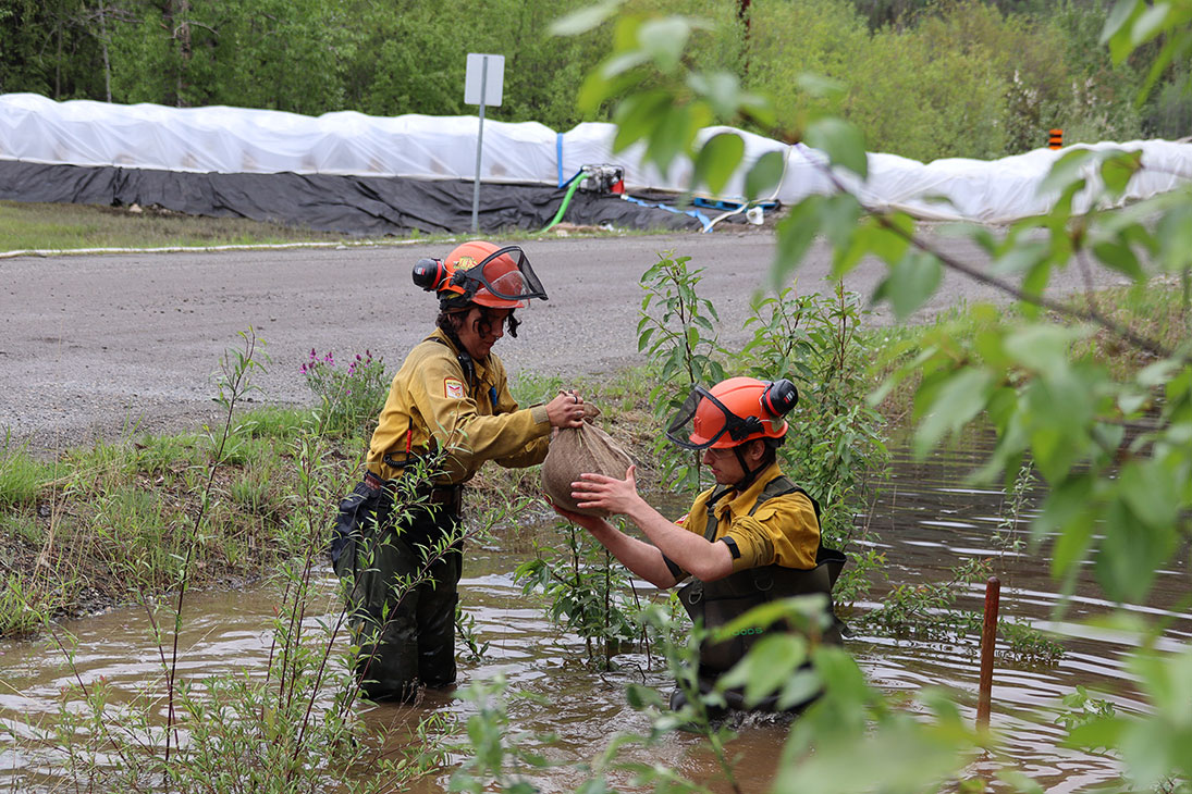
“Wildland firefighters and heavy equipment operators are building a superbag berm along the river, and using sandbags to secure more specific places. Crews are also installing pumps to remove water from behind the berm back into the river.”
The flood response team and the Ross River Dena Council are discussing ways to continue co-ordinating support for residents.
Community members affected by the flooding can register and ask for help 24 hours a day with Yukon Emergency Support Services by calling 867-332-7367. Ross River residents can call 867-332-1928 to speak to an incident official.
“A Government of Yukon incident management team is on site deploying pumps, sandbags and superbags with the help of Yukon
First Nations Wildfire,” the alert says. “The berm has been assessed and is holding.”
According to another statement issued Friday afternoon, in Pelly Crossing, the road to the Mica Bridge has been closed by the Selkirk First Nation as water has reached the top of the structure.
“In southeast Yukon, the Liard River is on flood warning and may reach 2012 flood levels by Sunday,” said Friday’s notice.
“Liard First Nation is responding with the support of (the) Yukon government. Resources in the region include 80,000 sandbags, 1,000 superbags and poly rolls for covering berms, plus a Government of Yukon crew and a sandbagging machine.”
In Dawson City, the government stated, “the Klondike River may cause localized flooding in Rock Creek.
“In Dawson City, the Yukon River is rising and pumps and sandbags are being deployed to protect infrastructure.
“Boaters should wear life jackets and residents should stay away from the eroding riverbank.”
The government also reported water is rising in Teslin and Carmacks.
“These communities are working hard to protect homes and infrastructure, and we are supporting these efforts with supplies and
personnel.”
In Whitehorse, there is some local flooding, but most creeks in the area are now dropping.
In Faro, the municipality is monitoring the river level to ensure that the drinking water supply and sewage infrastructure are protected.
High water levels have created a bit of the bottleneck near the Commissioner’s Residence across Front Street in Dawson City.
It’s not that there’s water on the road, but there is water flowing across the road.
A City of Dawson notice reads, “The Dawson waste water treatment plant is receiving inflows above its capacity.
“The Government of Yukon (which operates the plant), with support from the City of Dawson, has begun an emergency release of water to address the high inflows.”
Part of Front Street is now reduced to single-lane traffic, driving over an earthen mound under which a pipe has been installed inside a metal culvert to take the overflow from the waste water treatment plant to the Yukon River.
The pipe snakes from the plant’s treated water side, across the street, up onto the upper dike path and along that until it descends to the lower path, which is now mostly flooded. From there, it discharges into the river.
“This water will have some treatment but may not always meet treatment targets,” the notice says.
“Due to high dilution, emergency-released water is expected to have minimal environmental impacts. Water quality will be monitored
regularly.”
Dawson draws its water supply from several wells located between the dike and Front Street. These are upstream from the discharge.
– With a file from Dan Davidson
Comments (2)
Up 2 Down 9
Nathan Living on Jun 13, 2022 at 11:13 pm
So many Yukon communities at risk due to high water conditions.
GY should seriously consider moving a community. With planning the community could be used for safe nuclear power production tied into the grid.
Up 8 Down 10
Politico on Jun 13, 2022 at 9:02 pm
How can the conservatives blame this on the Liberals? There must be a way.