Photo by Photo Submitted
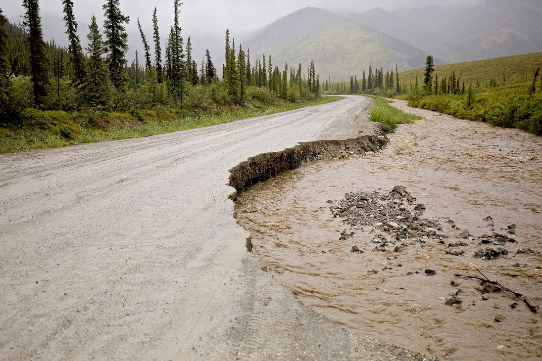
DEVASTATED DEMPSTER – High volumes of rain have left parts of the Dempster Highway in the condition seen here. Photos by JOE BISHOP
Photo by Photo Submitted
DEVASTATED DEMPSTER – High volumes of rain have left parts of the Dempster Highway in the condition seen here. Photos by JOE BISHOP
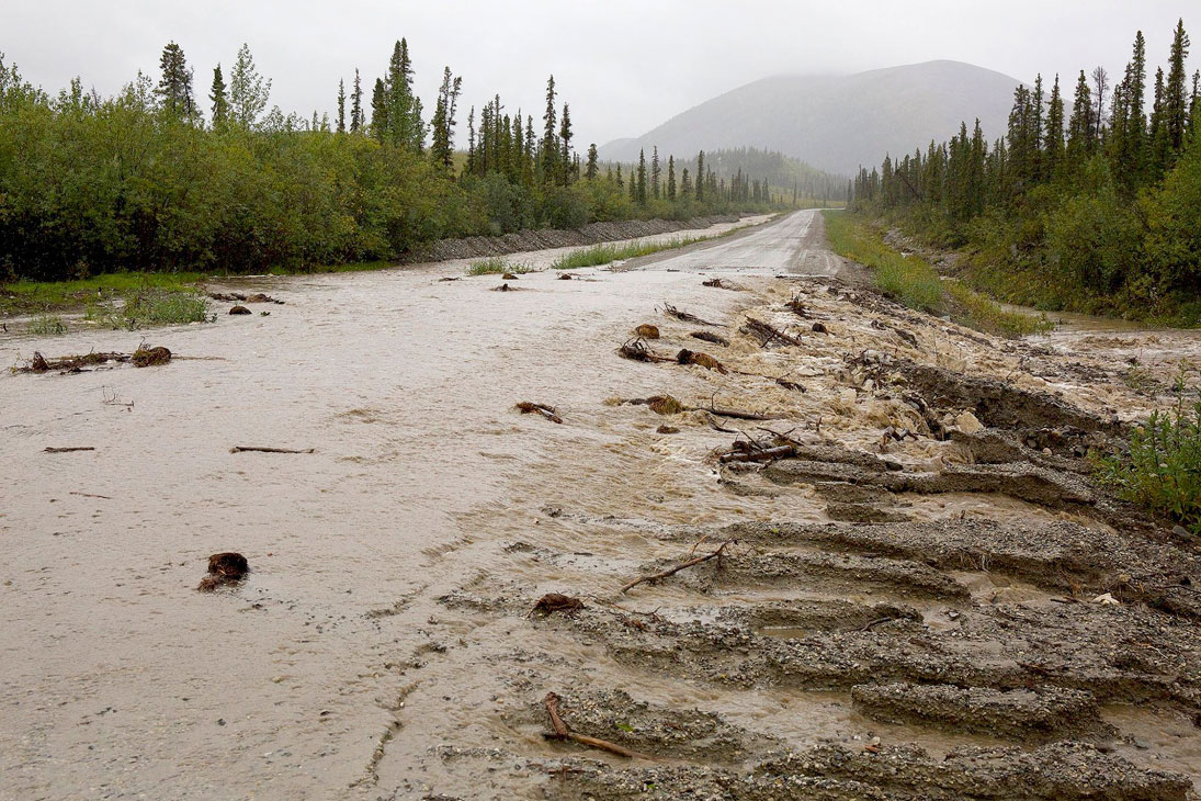
Photo by Photo Submitted
Photos by JOE BISHOP
Part of the Dempster Highway will be closed for several days as road crews work to repair damage from washouts at various locations north of km 136.
Part of the Dempster Highway will be closed for several days as road crews work to repair damage from washouts at various locations north of km 136.
Heavy rains and high water closed sections of the Dempster mid-day Thursday. The water is knee-deep in some areas.
Doris Wurfbaum, a spokesperson for the Department of Highways and Public Works, said Thursday afternoon it was expected a single lane would be open by the end of the day. Additional washouts, however, have changed that estimate.
Wurfbaum later said the turbulent nature of the water has slowed repairs, as crews had to wait for water to recede to work safely.
The closure is north of Tombstone Mountain.
With the Dempster’s reputation as a popular road trip route, the closure has impacted tourists as well as locals.
According to the Western Arctic Regional Visitor’s Centre in Inuvik, N.W.T., that hasn’t necessarily been a bad thing.
“The positive thing is (those who are stranded) have a little bit more time to experience more of what Inuvik has to offer,” travel counsellor Amber Ritias told the Star morning.
She said a lot of people do try to stick to schedules when they’re travelling in the North, but what they don’t realize is what can happen to schedules so far north.
“What a lot of people don’t realize is that driving up here to the Arctic is a whole other experience,” Ritias said.
Travellers know the highway is washed out, but they don’t fully grasp what that means until Ritias shows them photos of the roiling water and entire sections of missing roadway.
At that point, she said, it clicks.
“You know you’re really, really on an adventure.”
Ritias said hotels seem to be faring well, with no overbooking as a result of extended stays. She said prices at the grocery store also seem to be stable, though she notes the town doesn’t tend to see price increases until about a week after losing highway access.
As for this weekend, Ritias said a lot of people signed up for the caribou antler jewellery session at the Visitor’s Centre.
She was also recommending tours of the igloo church and the local greenhouse, a visit to see the library’s large northern book collection, and dropping by Saturday’s Arctic Market.
“Everybody has been generally pretty positive, I guess is the word, about the closure,” she said.
“A lot of people are like, ‘OK, that’s fine. That will give us more time to look around and go to these places,” she said.
“That’s a good thing.”
Stan McNevin, the longtime proprietor of the Eagle Plains Lodge, has been separated from the business by the washout and was unavailable for comment. The Star was told this morning only he can speak publicly about the flooding’s impact on the business.
The Dempster, which links the Dawson City area to Inuvik, officially opened in 1979.
Former prime minister John Diefenbaker, under whose vision the highway was created, had been slated to attend the opening ceremonies, but died 37 years ago this month, before they took place.
In order to encourage thoughtful and responsible discussion, website comments will not be visible until a moderator approves them. Please add comments judiciously and refrain from maligning any individual or institution. Read about our user comment and privacy policies.
Your name and email address are required before your comment is posted. Otherwise, your comment will not be posted.
Comments (2)
Up 8 Down 0
Peter Smith on Aug 13, 2016 at 5:52 pm
That wash out looks familiar. I worked on the Dempster back in the mid '70's when it was still a "dead-end" road that hadn't even crossed the Arctic Circle. In the spring of 1975 there were many washouts in the Ogilvie Valley that took out whole sections of the highway in a spectacular week of extremely high water. My most memorable summer was spent surveying the valley from the (then) 140 mile north to 154 mile where the road takes off, winding its way upwards out of the valley to the present Ogilvie look out. The outcome of that survey was raised grades and rip-rap placed along the rivers edge to prevent future wash outs. I hope the efforts there have paid off!
Up 18 Down 0
Peter Eisch on Aug 12, 2016 at 11:33 pm
We have been on the way back from Inuvik (visitors from Germany) and I guess the last car who went trough the washouts on the way south. The road was totally gone at the first washout and the water level beside the road went up from minute to minute. The Yukon Government road workers did show us a way how to make it through. We had a four wheel pickup camper and were able to drive beside the road, right behind us two nice elder local ladies who just followed us. The road workers were so nice to drive in front of us to the next one and showed us again how to make it through. We had to make it to three more by ourselves, but with the experience from the first two we were able to make it. Thank you very very much - you earned yourselves a medal, without your help we would have never been able to make it to Dawson.