Photo by Dan Davidson
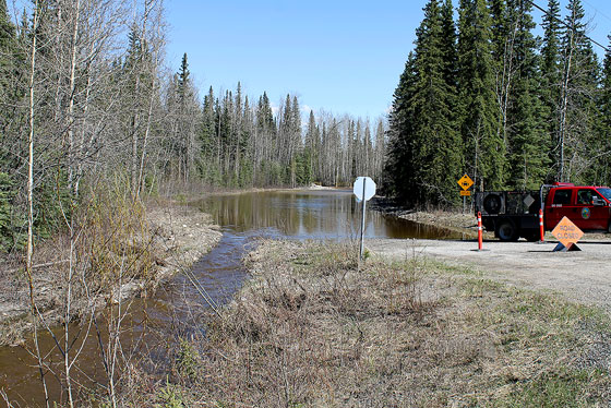
SPRING HEAT CAUSES MELTING – The entrance to the Rock Creek campground was flooded earlier this week. Most area residents have left.
Photo by Dan Davidson
SPRING HEAT CAUSES MELTING – The entrance to the Rock Creek campground was flooded earlier this week. Most area residents have left.
Most of the residents of Rock Creek have left the Dawson City-area community because of flood waters from the Klondike River, says the manager of the Yukon's Emergency Measures Organization (EMO).
Most of the residents of Rock Creek have left the Dawson City-area community because of flood waters from the Klondike River, says the manager of the Yukon's Emergency Measures Organization (EMO).
Michael Templeton said this morning most of the residents left Wednesday voluntarily, though some have stayed behind.
An emergency social service office has been established by the Department of Health and Social Services to assist Rock Creek residents who need it, he said.
Templeton said EMO would like all residents of Rock Creek who've left to register at the emergency service office even if they do not require assistance, just to help his organization keep track of who's left the community.
Minor flooding is also occurring in Ross River, and the Liard River at Upper Liard west of Watson Lake is rising slightly but is still about one metre below flood stage, he said.
In Ross River, Templeton explained, the water level of the Pelly River was beginning to come up last night on the shoreline down by the ferry launch. And there was a small breach in the dike this morning, he said.
He said staff with Wildland Fire Management were working at plugging the breach this morning, and ensuring residents were aware water was coming in.
One Ross River property was affected, but the water had not reached the home, he said.
The Stewart-Cassiar Highway, Highway 37, has been closed 80 kilometres north of Dease Lake because of flooding, according to B.C.'s Department of Highways.
Ross River and Rock Creek were both hit with flooding earlier this month because of ice jams on the Pelly and Klondike rivers, but this round of flooding is caused by the spring melt, Templeton explained.
Yukon hydrologist Ric Janowicz said this morning the spring melt could be a factor for another week or more.
The three areas that are having problems all experienced an above-average snowfall, resulting in a thicker than normal snowpack, he said.
Janowicz said the rising Klondike River at Rock Creek has settled down, and if it does keeping rising, he doesn't expect it will come up much more.
Ross River is currently 20 centimetres above flood stage, and could rise another 70 centimetres, he said.
Janowicz said while the Liard River is still a metre below flood stage at Upper Liard, he expects it will rise above the flood stage, but not by the devastating amount it did last year when some homes had water almost to the ceiling.
Following last year's flood at Upper Liard, the Yukon government purchased all 11 of the properties in the flood-prone area, through the federal flood relief program.
Templeton said a team was sent into the Rock Creek subdivision to assess the damage from flooding caused by the ice jam.
The assessment team will do the same again once the water recedes, and a report will be provided to the Yukon government to determine what if any action will be taken.
The exact number of people who've left the relatively small community south of Dawson was not available this morning.
The entrance to the Yukon government campground, which is also the north entrance to the road, was completely flooded by noon Tuesday. Water was rising near the south entrance, a few hundred metres from the Klondike Highway.
Moving north towards Dawson, Hunker Creek was pouring lots of water into the ditches alongside the highway. Water levels in both the Klondike and Yukon rivers had risen with the warmer temperatures of the last several days
Meanwhile, the disappearance of the ice and lack of substantial debris in the Yukon has enabled the City of Dawson to install the seasonal docks for the summer.
Janowicz said the flood season for the Southern Lakes doesn't normally occur until late July and early August.
It's expected the water will rise noticeably, but at this point, flooding is not expected, he said.
In Whitehorse, meanwhile, the Alaska Highway between Crestview and the Mayo Cutoff has been down to one lane of traffic today while crews repair shoulders eroded by high water.
– With a file from Dan Davidson in Dawson City.
In order to encourage thoughtful and responsible discussion, website comments will not be visible until a moderator approves them. Please add comments judiciously and refrain from maligning any individual or institution. Read about our user comment and privacy policies.
Your name and email address are required before your comment is posted. Otherwise, your comment will not be posted.
Be the first to comment