The Dalton Trail
Visitors to the Yukon and Alaska are always interested in the history of the areas through which they travel.
By Whitehorse Star on June 1, 1966
From the Whitehorse Star, 1966
THE DALTON TRAIL
305 Miles from tidewater to the river
By William D. MacBride
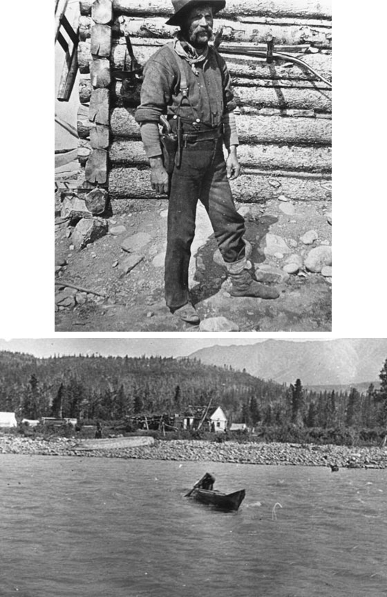
Visitors to the Yukon and Alaska are always interested in the history of the areas through which they travel. One of these is the route traversed by the Haines Highway, which follows to some extent "The Dalton Trail" of gold rush days - 159 miles from tidewater at Haines, Alaska, to Haines Junction. Mile 1016 on the Alaska Highway in Yukon Territory.
From the Archives of the Alaska Historical Library and Museum at Juneau, the Northwest Mounted Police, and photo albums and documents of Henry Dow Banks of Springfield, Mass. on a journey over the Dalton Trail in 1898, a brief history of Jack Dalton and his famous trail has emerged.
In 1898 the trail used early in the spring and late fall commenced from Haines Mission, and all freighting at that time could be done with wagons or carts to within three miles of the foot of Chilkat Summit.
The road passed through the Indian village of Klukwan and up the Chilkat river about three miles to its junction with the Klahena river and continues to Dalton Post. Both rivers had to be crossed and recrossed about forty times and as the wagons travelled only when the rivers were breaking up in the spring and just before they started to freeze up in the fall, nearly every crossing made was dangerous to man and beast.
In the spring the edges of the rivers were solid masses of ice, and in the centre a swift running stream, nessitated the wagons dropping several feet or more from the ice to the river bottom, and constant quicksands were also prevalent.
The poor condition of the trail induced Mr. Dalton to cut out and build a good trail for pack horses, from Pyramid Harbour to the top of the first summit a distance of about 60 miles. It was a trail which could be used from the time snow melted until very late in the fall.
About ten miles from Pyramid Harbour, the trail cut off to the south and entered a range of mountains, keeping away from the Chilkat river until opposite Klukwan at the mouth of the Salmon river. The crossing there was deep but not swift accept on very warm days when the water rose rapidly. Two men were drowned there in 1898.
The climb to Chilkat Summit, (not to be confused with the Chilkoot), was about 1700 feet of steep zig-zag trail, and was the only steep climb on the entire route. In general the road was free from rocks over firm sand, and easy on horses and cattle. All swamps or boggy places (and there were numerous) were corduroyed with small logs, and a good many substantial bridges built.
The laying out of the trail showed very good judgment. there were few steep grades and wherever possible a gradual incline was followed even at the expense of circling instead of climbing over a hill.
A toll of $2 per head was levied on all cattlemen going through, although having to pay the toll, gave Jack Dalton great credit for his trail job.
Dalton employed an American surveyor and his staff during the month of July, 1898, to make a survey of the trail and map out the route. He also applied for a charter under the Oregon laws, which then applied to Alaska Territory.
Boulder Creek is where he and other Americans claimed the international boundary to be, and it was where they ended the survey of the road. This creek is between eight and ten miles below the Dalton Trail Post. (A road to Dalton Post leaves the present Haines Highway about Mile 106. Nothing is left there now except a number of log cabins and a grave-yard.)
There were a large number of people in and around Shorty Creek Mining District (a few miles west of Dezedeash Camp, Mile 125 on present Haines Highway), but no policy near that point to intercept liquor being brought through British Columbia into the Yukon Territory. Police detachment was therefore placed at Dalton House, at the Crossing of the Alsek river, and a barrack was erected there in August 1898.
On Oct. 4th, 1898, a census of the inhabitants in and around Dalton House revealed a population of three white men and over one hundred Stick Indians. There are several lakes in the vicinity of Dalton House such as Klukshu, Dezedeash and the Kathleen lakes. Several families of Stick Indians were camped around these lakes.
The trail from the first summit led on over a good hard road covered with reindeer moss to Rainy Hollow, about eleven miles from the Summit. At this place there is a slope of over one hundred acres covered with a grass similar to Wild Timothy.
At Glacier Camp, twenty miles further on there were 26 glaciers in full view. The next stop was Bear Camp, 25 miles from Glacier.
The trail was fairly good, crossing over a large area called "Mosquito Flats," so named because of the ferocity of the insects infesting that sections. Bear Creek today is a small shallow stream emptying into the Alsek River used by the coast salmon coming up to spawn in the lakes. The trail crossed this creek to a point two miles further on, the first crossing of the Alsek river.
It continued through timber up a rather steep hill to where the British Columbia line (60th parallel) separates the Yukon Territory; thence on over a good trail to the second crossing of the Alsek, where Dalton House was situated, fifteen miles from Bear Camp.
Leaving Dalton House, the trail continued along a very steep hill for one mile from the detachment, then over a very good road to Klukshu Lake, a distance of twenty miles. Here another trail branched off to the left in the direction of Shorty Creek. (This trail is now followed by the Haines Highway along the west side of Dezedeash Lake.)
The next camp was Pennock's Post about thirty miles distant, then Camp Storey, eighteen miles. Pennock's Post, Champagne Landing and Camp Storey were points where Lieut. Adair's party built cabins for prospecting purposes.
The old trail continued to Hutshi Lake, head of the Nordenskiold Lake. (The Alaska Highway crosses the old trail near the settlement of Champagne, Milepost 974). It then followed the Nordenskiold river to near Five Finger rapids and Rink Rapids of the Yukon River, a point 235 miles from Dawson City.
The total length of the original Dalton Trail from Haines to the Yukon River was approximately 305 miles. The trail was used by a number of cattle drives. The cattle were shipped from Seattle, Washington or Vancouver, B.C. by ocean steamer, approximately 1000 miles, then driven over the Dalton trail to the Yukon river, and taken by scows down to Dawson City.
It was also patronized by pack trains, and by individuals on horse back. Dalton kept a number of horses at each end of the trail. An old Dawson newspaper stated that: "The Barringtons of Stikine river fame had a small steamer called the "Willie Irving", which operated from Dawson upstream to Rink Rapids, connecting there with transportation over the Dalton to Pyramid Harbour on Lynn Canal, 17 days Dawson to Seattle."
Dalton charged $150.00 for the trip from Rink to Haines including horse and maintenance, but the majority of the travellers elected to use the route to Skagway, Alaska.
After completion of the White Pass railroad from Skagway to Whitehorse in 1900, the Dalton Trail gradually faded away. The area it traversed became again an untravelled wilderness, except for some continuing mining operations, until the construction of the Haines Highway by the U.S. Army in 1943, at an estimated cost of $10,000,000.00.
A BRIEF SUMMARY OF JACK DALTON'S CAREER
1855 - Jack Dalton was born in the Cherokee Strip, probably in the present state of Kansas.
1874 - He worked as a logger at Burns, Oregon.
1882 -Spent some time as a cowboy on the Hadley Ranch in Baker, Oregon. Left to avoid prosecution for "shooting scrapes".
1883 - Went to San Francisco and shipped out as a seaman on a sealing vessel which wintered at Herschel Island, at the mouth of the Mackenzie River.
1885 - He was hired at Sitka by Fredrick Schwatka to accompany the New York Times expedition to Mt. St. Elias.
1890 - Accompanied the Frank Leslie Exploring Expedition from San Francisco to Chilkat country.
1891 - Was engaged for a private exploration of the Chilkat Pass by E.J. Glace, a writer for Century Magazine.
1892 - It is believed that he operated a small trading vessel in the Juneau area.
1893 - Was tried and acquitted for the shooting of Jack McGinnis, a cannery worker.
1894 - Leased a parcel of land and a warehouse at Haines Mission for the purpose of conducting a trading business with the Indians.
1896 - Established a trading route from Pyramid Harbour to the Yukon River near Rink Rapids, which included Pleasant Camp and Dalton Post.
1897 - Was hired by Goodall, Perkins & Co. to drive their cattle to the interior.
1898 - Guided parties over his Dalton trail.
1899 - Mining activity commenced at Porcupine Creek and continued until a flood in 1906 destroyed the flumes.
1903 - He built the Lindsay Hotel at Porcupine. Gold output on Porcupine Creek reached about $150,000 per year.
1905 - Made a financial settlement with Guggenheim interests in the Cordova Bay region for the construction of a copper ore loading terminal on his land. The amount paid was rumored to be upwards of $10,000.
1919 - Sold his Haines Hotel property to Steve Sheldon.
1921 - Went to the diamond diggings in British Guyana to investigate the interest of a group of Yakima, Washington business men.
1922 - Took up residence in Yakima, Washington.
1944 - Jack Dalton reached the end of the trail in San Francisco at the age of 89.
Be the first to comment