Snow adds misery to the spring that never was
Whitehorse saw record daily snowfall last night, but it's not expected to last.
By Max Leighton on May 16, 2012
Whitehorse saw record daily snowfall last night, but it's not expected to last.
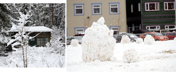
The evening's wintery weather left 22.5 centimetres (nine inches) of snow in parts of the community, Doug Lundquist, an Environment Canada sector specialist based in B.C., told the Star this morning.
"The cause was an upper low pressure system which moved north from the Watson Lake area,” he said.
The system dumped snow on Whitehorse and dusted Watson Lake, while Faro saw some rainfall.
Historically, snowfall in May is far from uncommon, though May 16 hasn't seen this much since Environment Canada began keeping records.
"Snow in May is almost always going to set a daily record,” said Lundquist.
"Though there have been days in May and June, which have seen more snowfall in the past.”
Whitehorse saw a particularly snowy spring in 1974.
On May 22 of that year, nine cm of snow fell on Whitehorse, while June 1, 1974 saw 13 cm of snow blanket the community.
The only month with no recorded snowfall in Whitehorse is July. In 1982, winter began in August for Whitehorse residents, as snow settled in and didn't leave until the spring of 1983.
This year has actually been a warm one.
"Whitehorse has been about one third of a degree above the normal average daily temperature for the last 30 days,” said Lundquist. "We have sat at about four to five degrees all month, which is slightly above normal for this time of year.”
Unrelenting winds made temperatures feel a lot colder than they actually were.
The 90-day trend has also seen above seasonal temperatures. Save for a brief dip in March, it's been "more above than below,” said Lundquist.
The unseasonably warm weather is set to return for the long Victoria Day weekend.
"We are looking at highs of about 12 to 16 C this weekend, where 14 has been the average temperature for this time of year,” said Lundquist.
"So, we'll be back to normal by the end of the week.”
The warm streak will probably extend throughout the Yukon, and there's about an 80 per cent chance it will remain into next week, said Lundquist.
"The moral of the story is, what goes up, must come down,” he said. "We are paying for the warmer weather we have had so far with precipitation, which this time of year still means snow.”
The heavy snowfall did leave a handful of residents without power in the Mary Lake, Golden Horn and Judas Creek subdivisions for several hours. The juice failed at about 3 a.m.
Yukon Electrical Co. Ltd. expected to have power restored by the end of the morning.
The snowfall made area highways slushy, but will not affect the opening of the territorial campgrounds, scheduled for this weekend. (See separate story below.)
The wacky weather saw local school students' annual envirothon postponed from today until tomorrow.
Whitehorse Minor Soccer has also cancelled action set for this evening due to muddy pitches.
Be the first to comment