Photo by Photo submitted
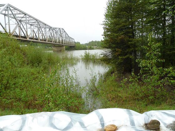
SLOW-MOVING THREAT – Extreme rain amounts over the last few days and seasonal snow melt have raised water levels in the Liard River at Upper Liard, seen Thursday in the photo above.
Photo by Photo submitted
SLOW-MOVING THREAT – Extreme rain amounts over the last few days and seasonal snow melt have raised water levels in the Liard River at Upper Liard, seen Thursday in the photo above.
The Upper Liard River is above flood stage and will likely rise another half-metre before peaking, says Environment Yukon's flood expert.
The Upper Liard River is above flood stage and will likely rise another half-metre before peaking, says Environment Yukon's flood expert.
Hydrologist Ric Janowicz said this morning from Upper Liard the river is likely to peak around the same level as the 2007 flood.
An unusual amount of rainfall and snowmelt at the higher elevations are causing the high water, he said.
"It usually peaks around the first week of June,” Janowicz said of the typical timing for the high water in the Upper Liard.
"Whether or not there is going to be a problem depends on the situation, and this year, there is a problem.”
He said approximately 70 millimetres of rain had fallen in the area over the last week, compared to what would normally be 10 mm in an average year.
"It has not peaked yet.” Janowicz said. "It's about 30 centimetres above flood stage and it's still rising at about two centimetres an hour. It will probably peak in the next day or so.”
He said the rate of how fast it is rising will drop off, but he expects it will still rise another half a metre before the peak.
Yukon Wildland Fire Management and highway crews are on-site reinforcing the 160-metre sandbag dike built in 2008 and 2009, as well as a second dike using much larger super bags being positioned by a heavy equipment excavator.
Wildland Fire Management spokesman George Maratos said today six firefighters from Whitehorse were sent to assist the five firefighters from Watson Lake who are going door-to-door to keep local residents informed.
There's been no alert evacuation nor order to this point, but residents are being kept up to date as circumstances change, he said.
"A lot of the residents went through the same situation in 2007.”
Maratos said the river has not yet come over the bank. None of the properties in the low-lying areas have been flooded, he added, but officials are keeping an eye on the situation in case additional diking around specific locations is required.
Janowicz explained the above-normal rainfall has come in the same year the snowpack up in the mountains of the Liard River basin is also substantially above average.
"So it is the rain that is the driving force, and the high elevation snowpack is contributing,” he said. "It is a rain-and-snow event.”
The flood of 2007 caused property damage in the Upper Liard area and the Southern Lakes, particularly the north end of Marsh Lake, where huge sandbagging efforts were required.
Janowicz explained lake levels in the Southern Lakes don't usually peak until early August, and are primarily related to the snowmelt in the higher elevations.
While the Southern Lakes area has also seen an above-average snowpack this winter, it's nowhere near the level of snowpack in the Liard River basin, he said.
Janowicz said it's too early to tell if lake levels will be an issue this summer.
Even though it's been rainy for the last little while in the Southern Lakes area, the longer-range forecast predicts a pretty normal summer season of precipitation and temperatures.
In 2007, the temperatures leading up to the flood were well above normal, causing an accelerated melt of the snowpack.
See related story below.
In order to encourage thoughtful and responsible discussion, website comments will not be visible until a moderator approves them. Please add comments judiciously and refrain from maligning any individual or institution. Read about our user comment and privacy policies.
Your name and email address are required before your comment is posted. Otherwise, your comment will not be posted.
Be the first to comment